The 10 Best GPS Units
This wiki has been updated 44 times since it was first published in May of 2015. You'll always know where you are, no matter your location, thanks to one of these high quality GPS units, which can then show you how to get to your destination. We've included models best suited for automotive installation, handheld devices for boating or hiking, and even watch-style options that are perfect for keeping track of your daily jogs and staying on top of your vital statistics. When users buy our independently chosen editorial recommendations, we may earn commissions to help fund the Wiki.
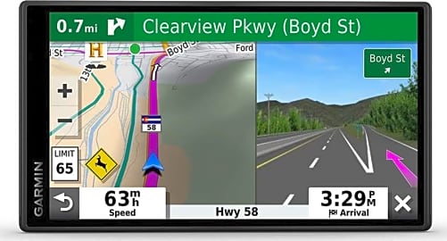
1. Garmin DriveSmart 61

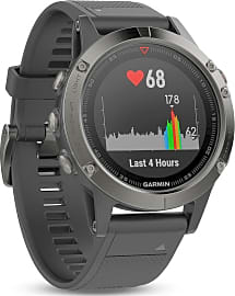
2. Garmin Fenix 5X Sapphire
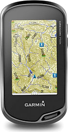
3. Garmin Oregon 750T
Editor's Notes
December 28, 2020:
During this round of updates, the Garmin DriveAssist 50 and Wahoo Elemnt were both eliminated due to availability issues. The Garmin Oregon 650T was still available, but we noted that it’s been discontinued by the company, so we went ahead and did some preventative maintenance, replacing it with its logical predecessor: the Garmin Oregon 750T
Our other new additions this time around are the well-lauded Garmin DriveSmart 55 — which features a 5-1/2-inch display with 1280x720 resolution and Wi-Fi connectivity; and the SkyCaddie SX500 — a GPS unit for golf that we thought might help diversify the page.
In addition to this general directory, we maintain several lists for GPS units with specialized purposes. So, depending on what you’re in the market for, you might also be interested in checking out our rankings for GPS backpacks, GPS dog collars, GPS units for motorcycles and GPS trackers.
We also keep a list of our favorite GPS cases.
June 17, 2019:
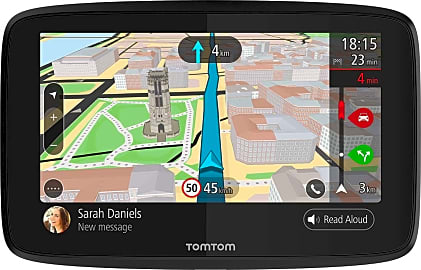
Whether you want to track your route or find your way to an unknown destination, a GPS unit can help. The best model for you will depend largely on your needs. If you want something for vehicular navigation, you'll want to take a look at the Garmin DriveSmart 61, Garmin DriveAssist 50, or TomTom Go 520. Of these three, the two Garmin models provide more alerts and easier to follow verbal navigation, but the TomTom Go 520 comes with access to worldwide maps, which requires an additional purchase with the Garmins. If money is no object though or you aren't planning on using it outside of North America, we recommend one of the two Garmin models.
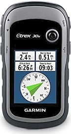
Hikers who plan on traversing wilderness trails should look at the Garmin Oregon 650t or Garmin eTrex 30x. Of these two, the Oregon 650t is the more full-featured model, coming with a built-in 8MP camera, a touchscreen, and 4GB of internal memory. On the other hand, the eTrex 30x is a more compact option and has a water-resistant display, so you'll have to decide which of these features are more important to you.
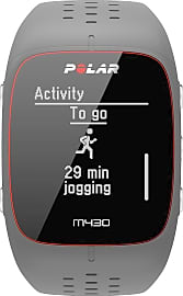
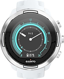
For the fitness buffs out there we have included GPS watches — the Garmin Fenix 5 Sapphire, Polar M430, Suunto 9 — and cycling computers — the Wahoo Elemnt and Garmin Edge 25. Of the three GPS watches, the Garmin Fenix 5 Sapphire seems to offer the best accuracy when tracking runs, and it is available in the most configurations. Of the two cycling computers on our list, the Wahoo Elemnt has a few features that give it the edge, like live tracking of friends who are out riding, a larger display, and turn-by-turn navigation. However, the Garmin Edge 25 is significantly more affordable, so if you are on a tight budget, it may be a better choice for you.
Special Honors
Here WeGo Many people may not be familiar with this software, but it is a serious contender to Google Maps and worth trying out. They have both a mobile app and a website, and they allow you to download maps for offline use. It is especially ideal for city navigation, as they provide live traffic information when available, public transport schedules, and more. wego.here.com
Maps.me If you know you won't have data service where you are going, then this is a smart choice for mobile phone use. It was designed specifically with offline use in mind. It offers worldwide coverage, supports offline search and navigation functionality, and has points of interests marked in many locations. It is opensource and free to download, but it does contain ads. maps.me
Google Maps Most of us by now know just how useful Google Maps can be. Whether you are using the desktop version or the mobile app, it has a simple interface that is easy to use. Conveniently, you can get directions for driving, walking, and even public transport. Plus, it works all over the world. google.com
4. Garmin DriveSmart 55
5. Polar M430
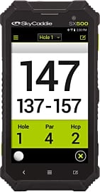
6. SkyCaddie SX500
7. Garmin eTrex 30x
8. Suunto 9
9. TomTom Go 520
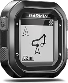
10. Garmin Edge 25
What Exactly Is GPS?
Its signal cannot, however, travel through very thick solid objects like buildings, which is why users often lose their GPS signal when they drive through tunnels.
Today, satellites are integral to the smooth operating of almost every industry, but as recently as forty years ago, they were predominantly used by the military. Global Positioning Systems (GPS), which are entirely dependent on satellites, were originally only available to the military, but the government gave the public access to this technology in the 1980s. GPS is made up of 24 satellites that the U.S. Department of Defense put into orbit in the late 1980s and early 1990s.
GPS, as we know it today, is the culmination of several previous systems, many of which suffered from a major issue; weather interference. Today, the satellites in orbit function under any weather conditions. The satellites go around the earth two times a day, following a specific orbit, and send information to GPS receivers on the ground.
Based on the time stamp of when the satellite sent the information, and the moment it arrived at the receiver, the latter knows exactly how far away the satellite is. The receiver then considers the distance measurements sent from the other satellites (it must be in communication with at least three to function properly), and using all of this information, it can locate where the GPS user is. When in contact with three satellites, a GPS is capable of producing a 2D location for a user. When in contact with at least four satellites, it can offer a 3D location, adding in altitude.
After a GPS has determined the receiver's location, it can determine other pieces of data, like the user's speed, the distance to their destination, and their bearing. GPS does all of this by emitting a low power radio signal that can go through glass, plastic and clouds. In terms of frequency interference issues, GPS has few. Its signal cannot, however, travel through very thick solid objects like buildings, which is why users often lose their GPS signal when they drive through tunnels.
What To Look For In A GPS Unit
While original GPS units were designed for military personnel, who are well-versed in jargon relating to longitude, latitude, and other distance markers, newer units are designed with the civilian in mind. Some, for example, use landmarks to help you know when to turn or stop. This addition might be especially helpful for women since studies suggest that they have great visual memory, and are better at navigating a city based on sites than geographical information.
If your GPS unit is primarily for outdoor use, make sure it is ruggedly built and water-resistant.
Travel photographers, particularly those who spend time in open nature, can benefit from a GPS unit that attaches to a camera and adds geotags to images. People who go on hikes, camping trips, and other adventures that take them away from luxuries like electrical outlets and Wi-Fi need a unit with a long battery life, so they don't get lost in the wilderness with a dead GPS. Adventurers usually have to carry a lot of gear and can't hold a GPS unit, so they should look for one that can be worn like a watch. If your GPS unit is primarily for outdoor use, make sure it is ruggedly built and water-resistant.
Some GPS units boast a large memory of up to 4 gigabytes, so they can save your maps and routes. One of the top causes of car accidents in America is a distraction from an electric device. If you're purchasing a GPS unit for your car, look for one with a built-in microphone so you can speak your destination to it rather than punch it in with your hands.
The History Of GPS
The first manmade satellite, Sputnik 1, was placed in orbit in 1957 by the Soviet Union. Soon after, two physicists at Johns Hopkin's Applied Physics Laboratory named George Weiffenbach and William Guier realized that, based on the Doppler effect, they were able to determine Sputnik's location. The two were soon given access to one of the first commercial computers, the UNIVAC, so they could further their research on the concept. Weiffenbach and Guier eventually discovered how they could determine the location of the signal receiver, which spurred the creation of Transit, the first satellite-based navigation system.
The USSR claimed they believed the plane was on a spy mission.
Transit was originally used by the Navy in the 1960s. It consisted of just five satellites and sent location information to the user every hour. In 1967, the U.S. Navy improved on Transit and it was eventually replaced by Timation, which utilized accurate atomic clocks in space. Timation allowed its users to know what time the satellites sent out information, making it possible to determine a receivers exact location at any time. In 1973, the government started launching a series of 11 satellites that would be the beginning of the NAVSTAR global positioning system.
In 1983, a Korean passenger jet flying from New York City to Seoul, South Korea was shot down by the USSR, after it accidentally veered from its path and strayed too close to their borders. The USSR claimed they believed the plane was on a spy mission. This not only spurred severe anti-Soviet sentiments in the United States but also encouraged the U.S. government to make GPS systems available to civilians. Their hope was that all forms of transportation, from shipping and cargo jets to commuter boats, would be constantly aware of their location, to avoid accidentally moving into restricted areas.


After deciding that the pen was mightier than the pliers, Canadian electrical contractor William Rhoda abandoned his career and headed back to college, where he majored in marketing and advertising and won a scholarship along the way to earning a diploma in creative communications. His past career landed him a depth of knowledge in tools and hardware, while his current career schooled him in audio, video and camera equipment. During his leisure time, he’s learned lots about outdoor gear, and years of tiresome backyard maintenance have taught him all about pools and hot tubs. His recreational pursuits include rest, relaxation and revolutionary action, and his roommate’s a hairless cat.